What is Everesting? http://www.everesting.cc/
The elevation of Mt. Everest is 29,029 ft. Each lap up Mill Mountain's Old Road is 807 ft. Do this 36 times and you've just rode up Mt. Everest!
This Strava Segment shows the route we plan to take.
Each lap is 3.88 miles round trip so 36 laps will come to about 140 miles…but hey half of that you'll be coasting!
Attempt Date: Friday May 29th 12:01am. Start time can vary for whatever makes the most sense for you and your goals for the day. Anticipate each lap will take 25-35 minutes plus breaks.
No one from Virginia has ever Everested a climb. Only 5 riders in the entire US have Everested. 149 worldwide. http://www.everesting.cc/hall-of-fame/ If you feel you can pull off 36 laps and want to be included in the Hall of Fame, be sure to read their rules. http://www.eversting.cc/the-rules
36 laps is crazy you say?! Don't despair only a select few elite athletes will be able to accomplish this amazing feat. But how many can you do? Just as mountaineers test their abilities and find the highest mountain to match their skills, you can do the same. That's why we are also setting several attainable mountains you can set your sights on.
The Frump Frump - 1 Lap
The Alpe d'Huez (climb equivalent)- 5 Laps
Mt. Rogers - 8 Laps
Machu Picchu - 10 Laps
The Alto de Letras (climb equivalent) - 13 Laps
Half Everesting - 18 Laps
Mont Blonc - 20 Laps
Denali - 26 Laps
Death Zone - 33 Laps
Everesting - 36 Laps
Set your goals and then exceed them!
This event is FREE! However, RSVP if possible so we can plan accordingly. Each rider will have their own paper pull tabs at the summit with information about each lap and to help celebrate each amazing accomplishment attained.
If you plan on Everesting you must use a barometric GPS to track your ride and it must be uploaded to Strava. You must also come down the same route you are going up and no changing the route as soon as you begin. I cannot stress the importance of reading the rules set by the Hells 500 group. If you do not plan on Everesting, then you may descend the New Road if you like because we honestly don't care.
As you enter your 12th lap there will be a mountaineering role play which will help you feel as if you too are climbing Everest. Each lap you will learn about the struggles and milestones of a real climber hiking towards base camp, camps I through IV and entering the Death Zone. By the end of the day you will have a greater sense of how big this mountain, and other mountains, really are because you will have rode them all!
Food and drinks may be stored at Underdog Bike (aka Base Camp) during their operating hours. Hopefully we can keep a cooler for food and drinks at the summit as well if someone is willing to watch over it. You are responsible for bringing your own food. If you bring extra food and decide to share it, we will have a table for 'pot luck' food.
There will be a group photo at the Star at 9 am. Anyone taking pictures with Instagram is encouraged to use the hashtag #Everesting to help the Hells 500 organizers follow our progress.
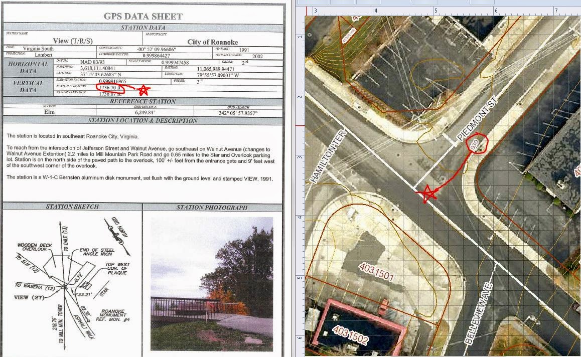
The picture below provides proof directly from the City Engineering Department that the elevation at Underdog is 930 ft. and the elevation at the Star viewing platform is 1737 ft.