
(2014 Date = 9.14.2014) What is the Virginia Endurance Series?
2013 GNM VES - Pictures LINK

Virginia Mountain Bike Trail from Adventure Seen on Vimeo.
Ride Start Time = 9am
Map of & Directions to Ride Start: http://goo.gl/maps/GFiwS
Ride Start Coordinates: 38.759543,-78.841171
This VES event will have 2 length options:
- GNM route which is a 4-6 hour ride (after climbing 568 turn left onto Great North Mt 1009 - see map below), and ...
- GNM + Trout Pond, Figure 8, 55 mile route (adds Thorny Bottom Rd and the Long Mountain Trail / 1007).
 |
| The overlook above Trout Pond. |
 |
| A view from the Great North Mountain ridge. |
- 15 miles west of Mt. Jackson, VA - Exit 273 on I81
- 25m Northwest of Harrisonburg
- 1h30m from Charlottesville
- 2h from Washington DC and Frederick, MD
- 2h15m from Roanoke
- 2h30m from Richmond
All trails (EXCEPT the two drawn in red trails in the image below) are easily visible on National Geographic Trails Illustrated Map #792 (click here to buy map #792):
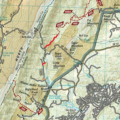 |
| The 2 drawn-in RED trails above are not on map #792 - please make note of them! |
Cue Sheet: Thank you Kyle Lawrence!
Parking: Tomahawk Pond on the east side of State Route 610. About 5 miles south of Basye on 610
- Head north on 610 for 5 miles to Basye
- Left turn onto SR 717 (Travel roughly 1.5 miles)
- Left turn onto Forest Road 1628
- Stay right on the road until it ends then you will continue north on a short piece of trail
- Trail ends up on SR 720 (Crooked Run Rd)
- Left on Crooked Run and start looking for blaze on north side of road at a switchback (Less than a 1/2 mile up)
- Follow the road (568A) past a handful of recent timber cuts until it turns to route 252 and around the gate
- You will pass two trails Falls Ridge (572) and Stack Rock (568B)
- Careful not to miss the turn for Laurel Run (568) it comes at a sharp bend in the road and will be on your left. Oftentimes, hikers park cars here and obstruct the gate/trail head
- Climb Laurel Run. At the top you can either choose the bonus loop dropping down to Trout Pond or begin your journey on the ridge of Great North Mountain (Trail #1009)
- (Optional) Trout Pond Directions: At the top of Laurel run, turn right onto 691 and look for a left onto 1007 (Marked with hiking sign)
- Drop down a fun descent and either take the Long Mountain Trail or shortcut it! and turn left to follow trails Trout Pond/Rockcliff Lake
- The climb out of Trout Pond can be found at the top of the campground and near one of the sites. You will climb past the well and follow the road all the way back up to the North Mountain Trail.
- (Optional) Trout Pond Directions: At the top of Laurel run, turn right onto 691 and look for a left onto 1007 (Marked with hiking sign)
- If you continue on Great North mountain you will have over 6 miles of beautiful ridge trail with a few incredible views. Make sure to REMAIN on 1009. The the intersection of Falls Ridge and Stack Rock can be tricky. You should never plummet steeply off the ride. before you reach the top of Crooked Run road.
- At the top of Crooked Run road, go around the tower and pick up the trail on the other side (not on the map)
- Continue on the ridge past Trail #420 (good bailout option) which will be marked with a hiking sign
- Follow the ridge all the way back to Trail #421 (Hunkerson Gap)
GPX File (Courtesy of Zack. Trail locations are approximate):
Overview Maps:

More Detail:


 |
NOTE: Ride Start / Tomahawk Pond is at route mile 27.95 on this map.
|
I made a GPX course for Garmin users - trail locations are approximate
ReplyDeletehttp://connect.garmin.com/course/4751602#